
Regular readers of Eindhoven News will know that recently a historical atlas of Eindhoven was released. This accessible, beautifully illustrated, English language history of the fifth largest city of the country was long overdue.
The combination of the 2020 centennial of Eindhoven’s merger with surrounding villages into its ‘greater’ incarnation and the 65th birthday of the Technical University in 2021 made this publication possible. Every city is a palimpsest, with layer upon layer of history, that may not always be evident to us non-historians, but strongly shapes what we see today. Knowledge about that history makes a lot of those layers visible and will open your eyes to the striking peculiarities of Eindhoven. Finally, Brainport’s large expat community has an English language book about the city’s long and distinctive history. And that it is a historical atlas, rather than ‘just’ a book, is an incredible bonus. The many maps and other illustrations make it very easy to spatially locate the history. It ties the stories to places that you and I know. After reading this atlas, next time you visit these places, your newly acquired store of insights, anecdotes, and other background information is sure to enrich your experience.
“Every city has its striking peculiarities, of course, but in Eindhoven, they do create a very remarkable whole” (Wilfried Uitterhoeve, Historical atlases series editor)
The atlas has 35 chapters dealing with the city’s history, and an additional dedicated section on the history of the TU/e campus. The first chapters deal with Eindhoven’s ‘deep’ history, from its prehistoric beginnings, through its centuries long-stagnant existence as a strategically located but relatively minor market town. The next chapters describe the importance of hooking the city up in the 19th century – first by paved road, then by water (the Eindhovensch canal), and finally by rail – for its industrial take-off.
All of that doesn’t make Eindhoven stand out yet. Only a very small number of Dutch cities saw much if any urban development until the 1850s. It was Philips setting up shop in Eindhoven, and rapidly becoming very successful, that changed the gears of urban development. I am sure you are aware of how much Eindhoven is a Philips’ company town, but the atlas is without doubt going to increase your appreciation of what that qualification really means. It changed the small market town into a patchwork of new industrial zones, working-class districts (and some villa parks for the corporate elite), in between the ribbon developments connecting the surrounding villages to the centre. But in addition to these ‘bricks and mortar’ contributions, the company’s cultural DNA, from providing service beyond just housing for its huge labour force (think education, food, sports and other entertainment, and more), to its emphasis on R&D and design, basically ‘made’ the Eindhoven as we know today. Much of the company town’s history is still with us in the form of (reused) industrial heritage, residential neighbourhoods, and more. And Eindhoven as the centre of the Brainport region is a direct consequence of that heritage.
This first ‘peculiarity’, the dominance and exponential growth of Philips, made the 1920 annexation of the five surrounding villages, creating ‘greater’ Eindhoven, inevitable. But the chapters describing the countless city and regional level planning efforts, that for many decades made surprisingly little progress, show that this annexation on its own was not enough to turn Eindhoven from an aggregate of villages into a proper city. WWII added a second ‘peculiarity’ that in the most literal sense created urgency and space which strongly influenced subsequent urban development: after Rotterdam, Eindhoven was the most heavily bombed city in the Netherlands.

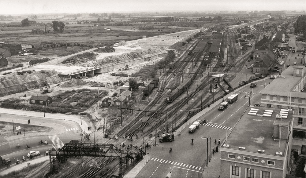
Although the post-WWII reconstruction plans were way more ambitious than what actually became of them, in the following decades the city centre changed considerably, although its medieval street pattern did largely survive (the previous article in this series on Exploring the Eindhoven Region specifically focuses on the reconstruction of the city centre). Most importantly, the formidable infrastructural barrier of the railway tracks was finally dealt with. This opened up the expansion potential of the nearly 27 square kilometres of Woensel’s largely open territory. The TU/e campus was one of the results of this focus on an extension to the North. But what really stands out, and resulted in Woensel being one of the largest urban extension areas in the Netherlands, is Eindhoven’s first Brainport like collaboration. From 1955 onward, the teamwork of the municipality, large enterprises (mostly Philips), and housing corporations were so successful that the housing stock grew much faster than that of larger cities like Amsterdam and Rotterdam. Another one of Eindhoven’s ‘peculiarities’ that added to its emergence as a very distinctive whole.
The map below, like all other images taken from the atlas, is a beautiful illustration of the cliché that one picture can say more than a thousand words. It shows how small the ‘original’ Eindhoven was, how little had changed by 1900, the growth of the company town until 1950 made possible by the annexation of the five surrounding villages, and the enormous expansion in the decades after WWII.
The historical atlas does a wonderful job explaining and visualising how, Eindhoven’s development remained an aggregate of ad hoc initiatives, determined by its fragmented structure of pre-existing villages and transport infrastructure. And that, in turn, was largely determined by the region’s landscape and geology. For such an ‘unplannable city’, as the authors characterise Eindhoven, a surprising amount of only partially implemented ‘master’ planning has gone on and continues to this day. As a history of the centre of Brainport behoves, the atlas peeks into the city’s future with chapters on the adaptive reuse of vacated industrial buildings (think Strijp-S, but more is on the horizon), the ‘densification’ of the city centre and Fellenoord (think many more high-rises, greener, less car-centric) and, obviously, the further development of Brainport infrastructure itself. A city history describing the future, Eindhoven’s peculiarities make for a remarkable whole indeed!

Let me end with some observations on the special section about the development of the TU/e campus that rounds off the Historical Atlas. Lots of the Eindhoven peculiarities, most importantly the focal role of Philips (in this case, hand in hand with automotive company DAF) and the knack for successful public-private collaboration play a role in the development of this Brainport precursor and current core facility.
“If you walk around the TU/e campus, you’ll notice the covered walkways that connect the departments, lecture halls, and laboratories. There is a research philosophy behind these walkways that is linked to the founder of the famous Philips Natlab, Dr Gilles Holst, who served as an adviser to the university in its founding years. These covered walkways between connected buildings, designed by architect Sam van Embden, encourage informal contacts between different disciplines. It is these contacts that facilitate cooperation and innovation on campus, but also with our partners in the Brainport region and outwards into the scientific world” (Foreword Historical Atlas, Robert-Jan Smits, president TU/e)
The extended section about the development of the TU/e campus is not the only chapter of the atlas that could double up as a ‘guidebook for the historically and architecturally interested’ but it is the most elaborate. If you haven’t yet visited, and enjoyed the campus landscaping, ‘industrial’ architecture, and interesting public art, reading this section is bound to convince you to do so soon. And if you do, the Eindhoven Architecture City guidebook (reviewed in an earlier article in this series) is a good pocket-size alternative to the coffee table Historical Atlas to take along on your visit.
Until the 15st of May, The Historical Atlas of Eindhoven is available for an introductory price of euro 24,95 (thereafter 29,95) so don’t hesitate!
For Eindhoven News: Roger Henke.
More background info, resources, and thoughts, visuals and audio about Eindhoven, The Netherlands, cities, exploring environments and assorted fancies: https://runandwalkeindhovenregio.org/
Episodes in the Exploring Eindhoven Region series:


