
Like everyone else who moves to Eindhoven, my wife and I soon discovered the city’s marvellous green lung, the Dommel river. This watershed, with its variety of brook valley landscapes, dictated early settlement patterns, and the possibilities for farming and affiliated exploitation. The river and its tributaries have had a huge influence on the development of the city and the region.
Over the last couple of decades, the Dommel banks have grown into a remarkable linear park that is testimony to a consistent municipal vision about the need for green space (but in its remaining discontinuities also to a lack of awareness about the importance of uninterrupted connectivity). Given that the Dommel green makes for such an obvious and seemingly straightforward walk, what is left to ‘explore’, what only reveals itself if you start actively looking?
Quite a lot actually! So I want to take you along on my personal journey of discovery which started with having a good look at what VisitBrabant suggests to those wanting to walk the Dommel valley. The link accesses an interactive map allowing you to design and print/download your own route. For a full-screen version, just for the sake of making sense of what follows below, click here (click on the hiking tab and keep the browser tab open so you can switch back and forth between the text and the map).
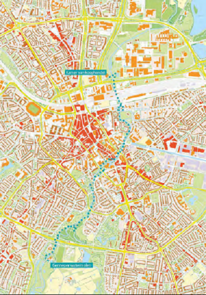
Starting at network node 25, close to the railway station, and staying within city limits, one can quite closely follow the river North all the way to the village of Nederwetten, and South all the way to the node of highways called the Hogt. Let’s go South first. For the inner-city stretch up to the Genneper park the tree wizard, about whose audio walks I wrote in my previous article, has written a guide (free download) which describes 48 interesting (groups of) trees between the Chambers of Commerce building at the entrance of the TU/E campus and the Genneper Watermill. Unfortunately, it is (still, any volunteer translators out there…?) only available in Dutch. However, it has several detailed maps with each tree of interest clearly indicated, and accompanying photo. So it is accessible enough for all you tree lovers: make good use of it! It only takes some basic bits of knowledge to open your eyes and realise there is something to see.
The bit of green on the Visit Brabant map (that is open in your other browser tab) in the Southwest elbow of highways is called the Klotputten, a name which recalls its history of peat (‘klot’) extraction. You can see that the VisitBrabant route circles a sludge trap before returning along the Dommel (or continuing South under the highway – but that is for another exploration). It is one of those larger but seriously underused green spaces only used by those living nearby. If you zoom in on the interactive map, enough additional trails inside the Klotputten show themselves to convince anyone that this green area merits a proper visit.
Having such a close look at the interactive map is one of the two basic tools for using the VisitBrabant routes as an inspiration for exploring on your own. All sections of the networks are designed upon the suggestions from municipality level committees of locals with a detailed knowledge of the lay of the land and its attractions. I’ve used it more than enough by now to assure you that within the constraints of its integrated-network-of-routes concept, they’ve figured out the best possible way to get from A to B. But obviously that concept does determine a ‘grid’ approach to route development. The simplest example of how this ‘constraints’ is that within such an approach, there is only going to be one route closely following the Dommel. That route may be the best possible mix of left and right bank segments for a one-way walk, but given such a nice linear park, nothing is wrong with following one bank on the way out and the other on the way back.
Another ‘constraint’ of the network is that the routes are designed for at least 50% unpaved, not max of unpaved. This results in a network with a great balance of being in nature and walkability, but some of us, including me, are mud junkies and tend to aim for a max of unpaved. That it takes mud junkies to detect room for ‘improvement’ shows why ‘constraint’ is actually a misnomer. It all depends on what one looks for. VisitBrabant’s choices are rooted in the common good, aiming at what works well for most. This objective is illustrated perfectly by the network’s final ‘constraint’ of note: it was designed for diversity, a mix of urban and rural, of cultural and natural heritage. That the result doesn’t always work optimally for those with a specific interest, e.g. for the architecture buff, or the trail runner, means that:
- If you don’t have a specific personal preference for what to come across on your outing, the VisitBrabant routes offer you the best of what is generally available.
- If you do have such an interest, their network is a great starting point for exploring and then designing your personal alternatives – which is what I am doing here with the Dommel valley as my example.
Final fun fact about these integrated networks: did you know their origin lies in the Belgian coal mines? When you think about it, it makes perfect sense that a network of numbered junctions connected by signed routes is a good way of navigating an underworld without any distinctive features. Hail to those who realised that it also makes perfect sense above ground! The concept was first applied to designing and marking cycling routes in Belgium and then moved across the border into North Brabant and from there rolled out across the whole of The Netherlands. What an immense improvement upon the previously existing situation which had countless beautiful but unconnected routes. The walking route version started quite recently, doesn’t (yet) cover the whole country, and doesn’t (yet) have a uniform signage system. But, as I said in my previous love song on these integrated networks, it is easy to forget how unique this infrastructural resource is. And you may take ‘unique’ quite literally: it doesn’t have an equal anywhere.
Now, let’s turn North from the city centre to illustrate an example of the second basic ‘tool’ for using the interactive map as an inspiration. Check the map in your open browser tab for what the options are when one is near Nederwetten. Below, I’ll show you what I came up with after several visits to this part of the valley.
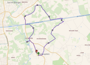 It is a loop beyond the municipal boundaries to the rim of Breugel village. To the Wilhelmina canal, I follow the VisitBrabant option; then I deviate staying on the dirt track along the canal before turning North on a trail that is not shown on the interactive map. That is the second ‘tool’ I was referring to earlier: be attentive to trails taking off in interesting directions and then be adventurous and see where they take you. The worst that can happen is that you have to turn back…In this case, it took me the Breugelsche Beek that is also on a VisitBrabant route. The fields near where both routes meet are home to a family herd of 80 water buffaloes, a sight to behold! Normally they are out in the fields, year-round, after 11ish AM. It honestly blew my mind coming across them one tropical summer day last August. Their farm, de Stoerderij, can be visited and sells products like mozzarella, paneer, and yoghurt from buffalo milk.
Taking somewhat different trajectories both our routes join again near the easy to miss Hooidonk water mill. The one real bonus of my version: it passes a field with two Belgian draft horses (in proper Dutch called knollen), which, again, are a sight to behold! And when you have a look at the water mill, make sure to continue another 50 meters to an unexpected bit of catholic heritage: a small chapel on the former site of a nunnery for women from noble families, made famous by a miracle in the 12th century (and later infamous, by the lavish lifestyle of its inhabitants). The small park surrounding it has a way of the cross by Dutch sculptor Piet Schoenmakers. The way back into town, whatever version you take, VisitBrabant’s or mine, will convince you that Eindhoven has a claim on being the country’s outdoorsiest big city.

Those interested in the full figure-of-eight 50+ kilometre Dommel valley route that I designed, based on a VisitBrabant template, can find it here.
For Eindhoven News: Roger Henke.
More background info, resources, and thoughts, visuals and audio about Eindhoven, The Netherlands, cities, exploring environments and assorted fancies: https://runandwalkeindhovenregio.org/
Episodes in the Exploring Eindhoven Region series:


