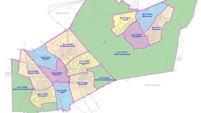
Over the past period, Geldrop-Mierlo has been examined to determine whether the current layout of the neighbourhoods is still ‘appropriate’. For example, Mierlo had no district division at all. According to the municipality, the area-oriented approach can be improved with a few adjustments to the existing layout of the neighbourhoods.
Mierlo is divided into four smaller districts: Neerakkers, Kerkakkers, Luchen and Mierlo-Dorp. A number of areas have been designated as rural areas, including: Gijzenrooi and the area around the four new Mierlo districts. Two small adjustments have been made in Geldrop: the corner at the bottom of Zesgehuchten – between the roads Gijzenrooiseweg, Emopad and Eindhoven-Weert railway – has been added to Genoenhuis. The Maison St Cyr’ building is now located in Braakhuizen-Zuid, instead of in Coevering.
Every municipality in the Netherlands is divided into districts and neighbourhoods. The Centraal Bureau voor de Statistiek (central bureau of statistics, CBS) is responsible for coordinating and compiling the various classifications. “A good and up-to-date district and neighbourhood classification is important to collect data for specific areas in a municipality”, a spokeswoman says. “This new district layout allows us to work better with our area-oriented approach. But it also helps in collecting and interpreting various data for policy development”.
Residents
Residents hardly notice any changes in the district layout in their daily lives. “However, the municipality increasingly wants to work from an area-oriented approach in the various areas and districts of the municipality. It is relevant that we have relevant data available about the area and the district. For this, a further division into neighbourhoods in Mierlo was essential”. For the area approach, the municipality also goes into the neighbourhood to find out ‘bottom-up’ what is going on among residents, entrepreneurs and social partners.
The district division of Mierlo took into account the origins of the village. “People who were born and raised here often already feel connected to a certain part of Mierlo. We took this into account when creating the new district division. Both in the boundaries of neighbourhoods and in their names. Residents will largely recognise this. The new classification has also been tested at Heemkundekring Myerle”.
The new classification came into effect retroactively on 1 January, 2024. This means that the municipality also complies with guidelines from the Centraal Bureau voor de Statistiek (central bureau of statistics, CBS).
Source: Studio040
Translated by: Bob


